
Patagonia and Tierra del Fuego had been on the list of Peter’s priorities for long time, one of the regions held in mind when Kiwi Roa was designed and built.
The interesting parts of Tierra del Fuego are perfectly suited to cruising via small boat; thousands of miles of channels and fiords make up the Chilean coast on the western side of the continent. This country is harsh and difficult. Most areas are extremely isolated, and the environment is unforgiving. Anchorages commonly do not deserve the label, frequently requiring shore lines in addition to set anchors. The weather is driven by the complex interplay of the Southern Ocean systems, the nearby Andes mountains, and the more immediate rough terrain, frequently resulting in unpredictable and violent winds. To the south, ice enters the picture as a constant hazard. Boaters inspired by the following Photo Story should recognize that this is not a cruising guide nor navigational aid.
Chilean Patagonia and Channels
Landfall after the 5,500 nautical mile passage across the Southern Ocean from New Zealand was made at Puerto Montt, immediately to the northern most extent of Chilean Patagonia.

Most vessels here support or work in the salmon industry. There are two docks, one for the fishing boats and one for the yachts.
In Estero Chope on Isla Puluqui, south of Puerto Montt in the Reloncaví Sound, is an aquaculture college. The area is dotted with mussel farms and two salmon farms at the entrance, navigation hazards for the visiting cruiser. The students at the college learn their practical skills on the surrounding farms.

Between Puerto Montt and Puerto Eden there are countless salmon farms, the product representing Chile’s second largest industry.

Ashore, the rolling rural countryside is reminiscent of northern New Zealand.
The bright colors of fishing villages contrast with the natural scenery.

The cloud above the landscape in the above photo is no normal cloud. Whilst Kiwi Roa was moving down the coast, on May 2, 2008, Chaitén Volcano some 30 miles inland to the east began its first eruptive phase in nearly 10,000 years. The Chilean government evacuated the nearby town of Chaitén, and ash from the ongoing eruption coated downwind sites and towns.

Inland sights make getting off the boat worthwhile. Volcan Orsorno meltwater from near Puerto Varas supplies the Rio Petrohué.

The channels to the south gradually become Patagonian in nature.

Seals are prolific in the Gulf of Corcovado, which separates Chiloé Island from the mainland of Chile.

Messier Channel is a fjord halfway between Puerto Montt and Cape Horn which marks the entry into Patagonia proper.

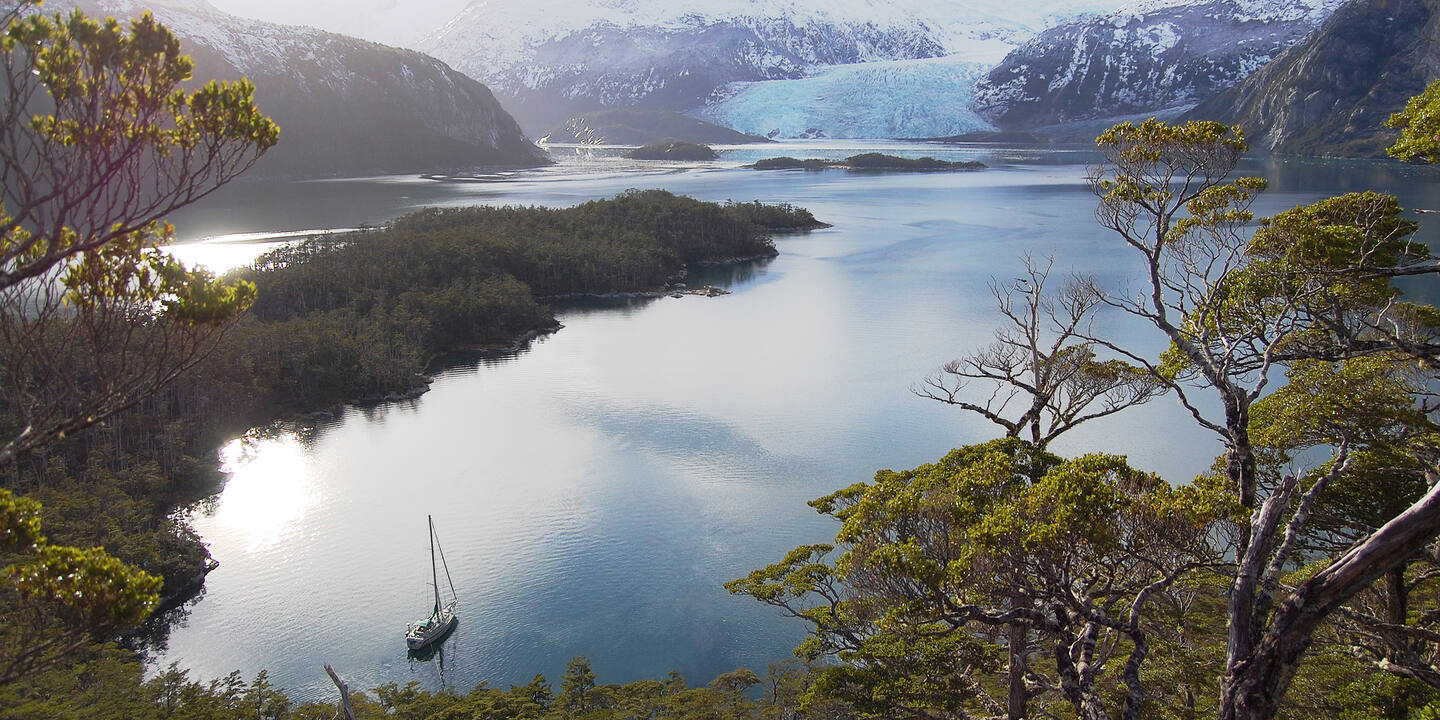
Glaciers are a primary feature of the landscape in Patagonia, and are best visited by boat. A number, including the below, are inaccessible by land. Many are located in national parks.

The brash ice collects in the sounds around the glacier face, an irritance to the vessel skipper concerned with his waterline paint-work.

Wrecks dot the channels, a warning from times before modern navigation aids. The Captain Leonidas steamship ran aground in Canal Messier in 1968 en route to Valparaiso and became a total loss.

Puerto Eden marks the point halfway down the channels. Belying its name, this very poor fishing village enjoys few facilities. The boardwalk shown below circles the whole village. The school, with the red roofing to the right, has the only internet connection in the 1,200 miles of the Chilean channels.

Wood is used for all heating, fires, etc. ‘Dead’ fishing boats litter many shorelines along the channels, especially in the northern parts.

On top of the hill in Puerto Eden is a shrine with the likeness of St. Pedro, the patron saint of fishermen. Typical in South America, the population is deeply Catholic, and these shrines are commonplace. Built and carefully maintained in strategic locations, the hope is that St. Pedro will protect the fishermen, who endure atrocious working conditions havesting centolla (giant crabs) in normally adverse weather conditions.
