
In distant memory are the Hiscock’s and company, those pioneering sailors who, during Peter’s childhood, planted the seed of a life on the sea – not only in him, but others germinating through the years into today’s cruising fraternity. Saint Helena always seemed to receive a whole chapter in these epistles, as it was an important stop in the long haul from South Africa to the Caribbean, Bermuda, or the Azores, on the final leg home to England in their tiny vessels. Thus told of through the generations, it became legendary, and Peter has long had it on his list of destinations for his own vessel.
Many years and ocean miles into his own sailing life, a number of ex-pat “Saints” are to be found working and settled on the Falkland Islands, characters who rekindled old dreams and firmed the island on Kiwi Roa’s itinerary for the passage after Southern Africa.
The island is no disappointment, as it has changed little from the descriptions given in those early days. This may be a fragile state of affairs however, as the new airport was well under construction during Kiwi Roa’s visit – and when open would drag the isolated Helenians finally away from the age of sail and steam, and into the modern one of mass tourism.
This collection of photos is spread over five pages. Boaters inspired by the following Photo Story should recognize that this is not a cruising guide nor navigational aid.
Transatlantic
Kiwi Roa left Namibia, northwest bound ultimately for North America. Saint Helena found itself of practical value for all shipping navigating this region in earlier times, the primary factor in its strategic value since about Drake’s day, and still of immense value for today’s cruising yacht.
In modern times a continuous watch is required for the increased shipping in these waters.

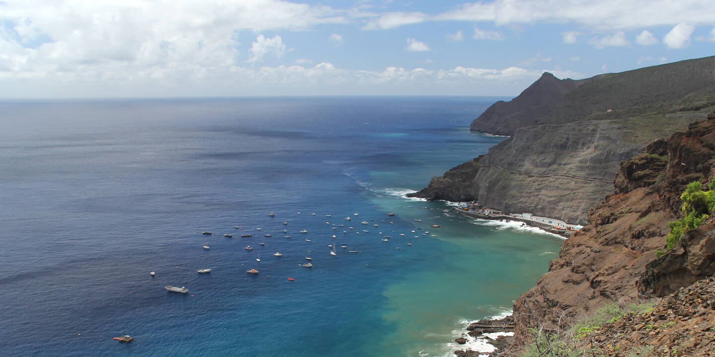
Landfall was made during the night at Sugar Loaf Point, the northern extremity of the island, and dawn brought us to James Bay.

A relatively new town suburb appears on the heights while Jamestown remains hidden in its valley, heralded by rolling and pitching vessels moored off the ‘Landing’ in the roadstead anchorage.

Stories abound of yachts lost through being poorly anchored or unattended, and moorings failing, in James Bay. A large yacht was lost only a year prior to Kiwi Roa’s visit, resulting in new and more reliable moorings being installed farther out in deeper water on the west side of the bay.

‘The Landing’, the only practical route ashore, can be tricky or even dangerous in a dinghy, depending on the swell running. The ferry service was accordingly well received.

The steep valley into which the original town is built constrains and preserves this historic Georgian town in a time warp. The one-way lanes built into the valley walls either side were originally intended for horse and cart, and other than some seal are little different today.

The fortifications across the vulnerable valley mouth are still much as original, although this entrance gate in 1832 replaced an original moat defensive system.

The “Castle” adjacent the Arch now houses the police station, the courthouse, and some municipal administration offices. The mortars are presumed decorative.

Saint James’ Church is the oldest Anglican church south of the equator, dating from 1774. Its tower originally featured a spire which nearly doubled its height, deemed unsafe and removed in recent decades.
